
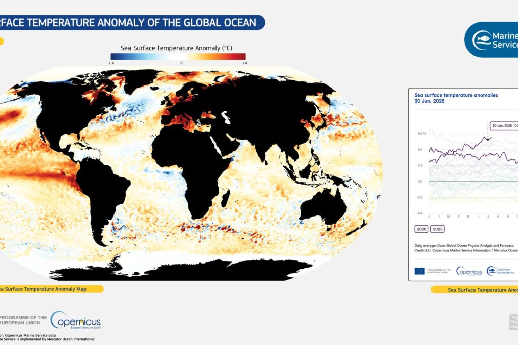
A potentially record-breaking El Niño event is developing rapidly in the tropical Pacific, bringing warnings of significant climate and ecological disruptions across the globe through 2027. The central and eastern equatorial Pacific entered an El Niño phase in May 2026, according to the National Marine Environmental Forecasting Center under China’s Ministry of Natural Resources.
Rapid Warming and Historical Context
By September 2026, sea surface temperature anomalies in the Niño 3.4 region reached +2.84 C, remaining above the El Niño threshold of +0.5 C for five consecutive months. Farther east in the Pacific, the Niño 3 region recorded an anomaly of +3.64 C, which points to a typical eastern-Pacific event according to the center. Forecasters expect the current event to peak in November or December 2026, with the Niño 3.4 index reaching around +3.5 C and the Niño 3 index exceeding +4 C. Jiang Hua, the center’s chief forecaster for El Niño events, noted in an interview with the Global Times that this trajectory would make it the strongest El Niño event on record since systematic observations began.
Historically, El Niño events occur every two to seven years and typically last nine to 12 months. The second strongest event on record occurred in 1997-98, when the peak reached +3 C. El Niño is a natural climate phenomenon characterized by the warming of sea surface temperatures in the central and eastern equatorial Pacific. Because El Niño events typically reach maturity toward the end of the year, it takes time for oceanic and atmospheric circulation to respond, meaning the most significant effects on China’s climate are expected in the spring and summer of 2027, according to Jiang.
The Mechanics of the Oscillation
The El Niño-Southern Oscillation is a global climate phenomenon emerging from variations in winds and sea surface temperatures over the tropical Pacific Ocean. A key mechanism driving this cycle is the Bjerknes feedback, named after Jacob Bjerknes in 1969. In this positive feedback loop, weaker easterly trade winds result in a surge of warm surface waters to the east and reduced ocean upwelling on the equator. This leads to warmer sea surface temperatures, a weaker Walker circulation in the atmosphere, and even weaker trade winds.
Ultimately, the warm waters in the western tropical Pacific deplete enough for conditions to return to normal, though the exact mechanisms causing the oscillation continue to be studied. El Niño events cause short-term spikes in global average surface temperatures lasting approximately one year, while La Niña events cause short-term surface cooling. The relative frequency of these two phases can affect global temperature trends on timescales of around ten years.
Immediate Impacts and Long-Term Risks
The unfolding super El Niño is already shaping seasonal forecasts for the United States. Winter Outlook released in October 2026 by the National Oceanic and Atmospheric Administration, warmer-than-average temperatures are expected across the northern United States during the winter months from December 2026 to February 2027. Wetter-than-average conditions are likely across the southern tier from California to Florida and along the Eastern Seaboard.
Beyond weather patterns, the physical changes carry serious risks for marine ecosystems and fisheries. Persistently high sea temperatures reduce dissolved oxygen in seawater, placing stress on the respiration of marine species such as fish, shrimp, crabs, and shellfish. Marine larvae are particularly vulnerable to this combination of high temperatures and low oxygen levels, while temperature fluctuations can alter fish population distributions and cause heat-sensitive species to die. While early effects are emerging in fishing grounds off the eastern Pacific coast near Peru and Ecuador, negative effects on China’s coastal fisheries and marine aquaculture may emerge later and become more pronounced in 2027, according to Jiang.
Global Agricultural Impacts and Food Security Concerns
The unfolding El Niño event is expected to have far-reaching consequences for global agriculture, particularly in regions heavily dependent on rainfall for crop production. According to the National Marine Environmental Forecasting Center, the altered weather patterns associated with El Niño can lead to droughts in some areas and excessive rainfall in others, disrupting planting and harvesting cycles. Countries bordering the Pacific Ocean, which are often developing nations reliant on agriculture, are particularly vulnerable to these changes.
In Southeast Asia, for instance, El Niño-induced droughts could reduce rice yields, a staple crop for millions. Conversely, excessive rainfall in parts of South America may damage crops such as coffee and soybeans. These disruptions could exacerbate food security issues, especially in regions already grappling with economic challenges. Jiang Hua emphasized that the impacts on agriculture could persist beyond the El Niño event itself, affecting global food supplies and prices well into 2027.
Defining the Super El Niño Threshold
While the article notes the event’s strength, the specific meteorological criteria distinguishing a “super” El Niño from standard events remain central to understanding its severity. According to the National Marine Environmental Forecasting Center, the current event is projected to see the Niño 3.4 index reach approximately +3.5 C and the Niño 3 index exceed +4 C. These figures are not merely elevated; they establish a benchmark that surpasses the peak of +3 C recorded during the 1997-98 event, which currently holds the distinction of being the second strongest on record.
Jiang Hua, the center’s chief forecaster, clarified that since relatively complete ocean observation records became available, no event has exceeded these projected values. This distinction is critical because the intensity of the sea surface temperature anomaly directly correlates with the magnitude of subsequent global climate disruptions. By exceeding the +4 C threshold in the Niño 3 region, the 2026 event is categorized as the strongest since systematic observations began, setting a new historical baseline for future comparisons.
Sources
- Heightened vigilance needed in spring and summer 2027 due to super El Nino event
- El Niño–Southern Oscillation
- El Nino looms large over U.S. Winter Outlook
Photo: European Union, Copernicus Marine Service Data (Attribution)




